Monday, 30 August 2010

Day 11 Kingshouse to Tyndrum

Monday 30th August 2010

After a surprisingly cold night I woke realising that camping in a communal area has it's pros and cons. It had been nice going to sleep knowing that you're surrounded by like minded folk. But a tent on my right played Elvis music until the early hours, and a man in the tent to my left sounded like he was in training for the world snoring championships.

The sun was shining for a change as I set off to continue my southward journey on the West Highland Way. The first section today climbed up close to ski lifts at the Glencoe Mountain Resort. It was a relief that the surface nearly all day today was better than yesterday. The path was more like cobbles now, far from perfect, but much better than rubble and rocks. Also there was the bonus of bridges over the streams

The path then passes through the spectacular Highland wilderness of Rannoch Moor until you reach a short stretch of tarmac road leading to The Inveroran Hotel. From the hotel the path leaves the road and goes up a steep path to cross a ridge. This climb was the toughest of the day, sticking to the road looked like an easier option, but the views over Loch Tulla from the top were fantastic.

After The Bridge of Orchy, a scenic spot where I stopped for a cold drink, the path continues along the foot slopes of a mountain following the railway line until it reaches Tyndrum. Surely Tyndrum must be smallest town in the country to have two separate railway stations. I found the local campsite, pitched my tent then made the most of the camp showers after a day in the sun.

GPS data click here

Mileage today; 19.40 miles, walking time 5 hrs 16 mins, average walking speed 3.7 mph

Weather; sunny, Max 17C

Cumulative mileage; 251.89 miles
A view of Loch Tulla
Rannoch Moor, unspoilt Highland wilderness

The Bridge of Orchy


Sunday, 29 August 2010

Day 10 Fort William to Kingshouse

Sunday 29 August 2010

The West Highland Way out of Fort William follows a road next to the River Nevis for a while, then you turn off onto a track which gradually climbs as it takes you up into the mountains. It's not long before you're looking at breathtaking Highland scenes, classic picture postcard views in every direction. There's a price to pay though, the tracks are very tough on your feet, basically you're walking on rocks and rubble and it's always going either up or down. In countless places streams flow across the path and you do your best to get across by looking for submerged stepping stones. I was very glad my boots were still waterproof.

Putting up with the rugged terrain is well worth it though, I can't think of a better way of seeing the Scottish Highlands than walking through them. Again and again my camera came out as more marvellous landscapes came into view.

From mid morning onwards there was a steady stream of walkers going the opposite way to me, most people walk the West Highland Way from south to north. This was clearly a much more popular route than the Great Glen Way, where I saw hardly any other walkers at all. Judging by the accents today it seemed at least half were from overseas, the West Highland Way must have international repute.

The steep climb down into  Kinlochleven was very tricky underfoot, it seemed closer to rock climbing than walking to me. The tortured faces of those coming the other way showing it wasn't much fun going up either. The van I saw in town marked 'West Highland Way Baggage Transfer Services' explained how some of those walking managed to travel much lighter than others.

After a break for lunch in Kinlochleven I got back down to the walking. The path goes alongside a series of huge waterpipes for a while, it looked to me like they emerged high up from the top of a mountain. Unfortunately I had to climb that mountain, eventually passing the top of the pipes that I'd looked up at from far below. That track going up out of Kinlochleven was very steep and went on for ages, it was even tougher than the Berriedale Braes back on day 2.

More amazing scenery and difficult tracks followed. During this stage I reached the highest point (550m) of the West Highland Way, and possibly my whole walk, at the top of The Devils Staircase. The name just about sums up the Devils Staircase, it would be bad enough if it were a tarmac pavement, unfortunately the surface is loose rubble and rocks. Believe me, that is not good news for already tired feet. About a third of the way down I saw a very sweaty mountain biker struggling to push his bike up this dreaded hill. He offered me twenty quid if I'd take his bike the rest of the way to the top, and I don't think he was joking.

Were the path briefly meets the busy A82 (an unpleasant reminder of the busy roads that await me later in my walk) I stopped for a few minutes on a bench to admire the Glencoe mountains and refresh myself with a drink of water. I noticed the bench was dedicated to the memory of 3 men killed in an avalanche nearby in 1995.

A further 3 miles or so along the track I reached my goal for the day and set up camp in an area behind the remote Kingshouse Hotel where wild camping is permitted. I was very tired after a tough but exhilarating day. My venison casserole and beer in the hotel went down an absolute treat. Today had been amazing, surely my walk can't get any better than this?

GPS data click here
Mileage today; 24.45 miles, walking time 7 hrs 7 mins, average walking speed 3.4 mph

Weather; morning overcast with showers, sunny spells in the afternoon,  breezy. Max 15C

Cumulative mileage; 232.49 miles
The cairn at the top of the Devil's Staircase, Glencoe in the background
Looking back towards Fort William after a long climb, Ben Nevis on the right

One of the locals


Saturday, 28 August 2010

Day 9 Clunes to Fort William

Saturday 28th August 2010

After a very wet night I had packed away my tent by 8-30am and headed off out of the forest. After walking along a section of road lined by expensive looking big houses the Great Glen Way follows the shore of Loch Lochie. This was a very pleasant spot and easily the highlight of the day.

After rejoining the Caledonian Canal at Gairlochy I walked along a 7 mile stretch of towpath being buffeted by headwinds and light showers in the shadow of Ben Nevis. The towpath takes you to Neptune's Staircase. It's quite a sight, a series of 7 locks that bring the canal down to sea-level.

After a couple of confusing miles the Great Glen way brought me to its end in the centre of Fort William. I had managed the journey in two and a half days, the guide books suggest it should take six.

After stopping for lunch in a large supermarket I made my way to my accommodation. The room was basic, but I was delighted to find I had a bath rather than the usual shower cubicle. My legs were soon enjoying a well deserved soak as I contemplated my next task, The West Highland Way.

GPS data click here

Mileage today; 17.85 miles, walking time 4 hrs 33 mins, average walking speed 3.9 mph

Weather; Overcast and breezy, light showers. Max 16C

Cumulative mileage; 208.04 miles

Neptune's Staircase viewed from the bottom
Looking back at the Clunes Forest, far left, where I camped through a very wet night.

Loch Lochie shoreline walk

Day 8 Balbeg to Clunes

Friday 27th August 2010

Today started with another 5 miles of hiking along forest tracks until I reached the first small town of the day, Invermoriston. On the way it was reassuring to see 2 other tents in clearings and realise that I wasn't the only person who'd spent the night in the forest.

The cafe in Invermoriston would've had my business if it were open, but it was still shut at 10-00am during the peak tourist season. My money was spent in the convenience store instead. Rejoining the Great Glen Way there was a short sharp climb out of town, then more forest tracks all the way to Fort Augustus. The glimpses of Loch Ness were spectacular again, but disappointingly infrequent.

Fort Augustus, at the south west end of Loch Ness, was a very pleasant place to stop for lunch, I relaxed for an hour there watching boats navigate the pretty locks. Whilst here I indulged in another local delicacy, Irn Bru.

When I continued on my way there was a welcome change, the endless hilly forest tracks were gone and I was treated to a flat walk along the tow path of Caledonian Canal. Not a single pine tree to hide the scenery. The flat grass section where the path starts to follow the bank of Loch Oich was a treat for my feet after all the rocky surfaces of the last day and a half, it almost felt like walking on a luxurious carpet.

For a few miles the path follows the peaceful shore of Loch Oich, some of it on a disused rail bed. I found the remains of Invergarry Station, abandoned in 1942, particularly fascinating. Where the path crosses the A82 at Invergarry I took my next break on a grass verge.

Only a mile or two further down the canal I was easily persuaded to stop again when I stumbled across The Eagle Barge Inn at Laggan Locks. It is quite literally a pub and restaurant on a docked boat. I left an hour and a half later with some hot food and a couple of pints in my belly feeling all the better for it. The laugh-a-minute landlord was a great character who made all the customers feel very welcome.

After Laggan Locks the Great Glen Way turns into forest tracks again, though flatter and less rocky than previous sections. I pushed on for over another hour, but when one of the afternoon showers, which had been light up to that point, turned into a cloudburst I hastily erected the tent and settled down for my 5th night under canvas in Clunes Forest.

GPS data click here

Mileage today; 29.39 miles, walking time 7 hrs 36 mins, average walking speed 3.9mph

Weather; Sunny spells, afternoon showers. Max 16C

Cumulative mileage; 190.19 miles
The wonderful Eagle Barge Inn
Fort Augustus, Nessie is big business here

A rainbow over Laggan Locks


Thursday, 26 August 2010

Day 7 Inverness to Balbeg

Thursday 26th August

Leaving the guesthouse today I felt fully refreshed and raring to get going again after my rest day. My bag seemed lighter than before, in part because I'd posted one of my books home, but once I'd stocked up with provisions at the local Tesco it seemed to be more or less back to it's normal weight.  As I wandered out of Inverness looking for the start of The Great Glen Way I was once again the owner of a waterproof jacket, I had also vowed to be more careful with my kit in future.

It was a bright sunny start as I climbed up several steepish hills heading out of town. For the first few miles the Great Glen Way is actually a bit of a let down and the name doesn't seem at all apt, you don't see any Glens or Lochs, just millions of pine trees as you walk along a series of forest paths. Mind you, this was still a very welcome change of scenery to me after spending so many miles dodging traffic on the A9.

After about a 5 mile stretch without seeing a single soul I met a scruffy, bearded long distance walker heading the other way. After enquiring where I was going and offering me his advice on a few things he told me what he was up to; a Z shaped walk from Dover to Cape Wrath via Lands End, John o'Groats and the summits of 3 mountains. Apparently this friendly chap had already walked over 2,000 miles and camped all the way. And I thought I was mad!

Not long after that interesting conversation I realised I had made a clumsy navigational error and accidentally wandered off The Great Glen Way. Luckily this soon turned into a blessing in disguise, while taking a path through The Abriachan Woodland to get me back on track I came across a tranquil viewpoint with stunning views across Loch Ness. This was easily my favourite beauty spot on the walk so far and I enjoyed an hour long break there admiring the fantastic scenery with the sun shining.

My next stop was at the town of  Drumnadrochit, close to Urquart Castle. As I enjoyed an ice cold drink from the local store the town was buzzing with visitors, many of them had bought Nessie souvenirs.

It was 4-00pm by now and I'd already covered around 20 miles, but I was keen to press on. Once I rejoined the Great Glen again it was very quiet again, deserted in fact. When my GPS device told me I had walked 27 miles I thought it best to start looking for somewhere to camp. In a forest on the side of a steep mountain that's not as easy as you might think, it was another couple of miles before I found a suitable spot. Annoyingly the midges were out in force as I hastily erected the tent, hundreds of them swarming around me. I settled down for the night thinking that today had been very different from my first 5 days, and very enjoyable too.

GPS data click here

Mileage today; 29.09 miles, walking time 7 hrs 30 mins, average walking speed 3.9 mph

Cumulative mileage; 160.80 miles

Weather; morning and early afternoon sunny spells, then light showers. Max 16C.
After accidentally straying off The Great Glen Way I found this superb viewpoint overlooking Loch Ness
Much of the day was spent on forest tracks like this

Urquart Castle


Tuesday, 24 August 2010

Day 5 Alness to Inverness

Tuesday 24th August 2010

Today started with me cooped up in my tent waiting for the rain to cease, frustrated that I was unable to continue without my lost waterproof jacket. Fortunately I didn't have to wait too long, at around 9-00am the rain seemed to stop, so I packed up my tent, emerged from my soggy field and headed south on the A9. Unsurprisingly the first few miles were an unpleasant and busy stretch of road.

After a while, with light rain falling again, the huge Cromarty Bridge came into view. On my approach I was delighted to see many seals playing in the water and relaxing on the rocks. It was also good news when I saw that this particular bridge actually did have the luxury of a footpath. Halfway across the bridge was reduced to a single narrow lane with temporary traffic lights because of roadworks. When I reached that section one of the workers told me I would only be allowed through with an escort. To my embarrassment all the traffic on this busy A road was halted in both directions while we walked through the narrow zone. Typical British humour came to the fore at this point, the colleagues of the worker who escorted me through made several interesting suggestions, including that perhaps he should escort me all the way to Lands End! As we parted he pointed south and said "keep going that way, it's about 750 miles", I left the bridge with a broad smile. As if to deliberately add to my good mood at that very moment the sky finally began to brighten and the rain stopped too.

After a seemingly never ending gradual uphill slog on another tedious stretch of road I reached the local services at Tore. Here I stopped and took my only break of the day. While I was relaxing in the diner a generous trucker who had asked where I was walking thrust a tenner in my hand for MacMillan Cancer Support.

From Tore I again had the opportunity to leave the A9 and make use of some quiet country lanes. When I had no choice but to rejoin the A9 close to Inverness it was almost like a motorway and I found myself having to cross a very busy section of dual carriageway. Entry to Inverness was via the fine Kessock Bridge, Inverness Caledonian Thistle Football Club's home ground was just over the other side. With the sun shining I wearily made my way to my B&B, I'd made my first landmark city a day earlier than expected and was feeling very happy with my progress so far.


GPS track; click here

Mileage today; 19.92 miles, walking time 5 hrs 2 mins, average walking speed 4.0 mph

Weather; occasional light rain, dry and bright to finish, max 17C

Cumulative mileage; 131.71 miles


My hideaway for a wet night close to the A9 at Alness
About to cross the huge Cromarty Bridge
The sun comes out as I enter Inverness via the impressive Kessock Bridge

Day 4 Dornoch to Alness

Monday 23rd August 2010

After a hot shower and a whopping breakfast my legs, which had felt quite stiff when I got up from the dinner table the previous evening, now felt remarkably fresh and I was to keen to put in another day of good mileage. Fortunately early morning rain ceased just before I hit the road, but it was overcast and grey, so after a couple of hundred yards I thought it best to stop and put on my high visibility vest.

I set off at a good speed and after crossing the windswept bridge over the Dornoch Firth and passing the Glenmorangie distillery I stopped at a shop in Tain to buy food and drink for the day. Without stopping at Tain for a rest I continued straight on, leaving the A9 and heading towards Alness on The Scotsburn Road. This quiet rural road wasn't particularly interesting, passing through forests and typical agricultural land, but it was peaceful and made a welcome change from the HGVs and speeding traffic on the A9.

On the Scotsburn Road a kind Scotsman in a camper van pulled over and offered me a lift to Inverness if I was going that way, I politely declined after explaining what I was doing. At this stage of the walk my temptation to accept the lift on a scale of 0 to 10 was a resolute 0. After walking the first 6 miles or so of The Scotsburn Road I stopped to rest and eat lunch, while tucking into my sandwiches and reading my book light rain began to fall on my back. This was when I realised I had my first problem of the walk, I went into my rucksack to get my waterproofs, but the jacket, which rolls up into a small net about the size of a cricket ball, was missing. When leaving Dornoch earlier I had made sure it was at the top ready for quick retrieval as rain was forecast, but I must have knocked it out of the rucksack and gone on my way without realising during one of my two stops earlier. Turning back was out of the question, I pressed on towards Alness at a good rate of speed as the rain gradually got heavier.

As soon as I made town I walked up and down the high street looking for a shop that sells outdoor gear but there was nothing suitable. After taking shelter for a while at the train station I decided to retreat to a pub and wait for the rain to stop. Three hours, three pints and a hot meal later it was becoming clear that the rain had set in for the night. My 25 mile target for the day was now out of the question. In the evening gloom I sneaked off to a field next to the Alness Point Enterprise Park and camped for the night. In typical "sod's law" fashion it was to rain continuously for 16 hours from the moment I realised the jacket was lost.

GPS data; click here

Mileage today; 23.24 miles, walking time 5 hrs 48 mins, average walking speed 4.0mph.

Weather; A dull morning, then rain. Max 16C

Cumulative mileage; 111.79 miles.

Arriving in Tain
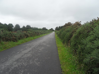
The Scotsburn road, a welcome reief from the busy A9
'Twenty's Plenty' in wet Alness. Are they trying to tell me something about my daily mileage?

Day 3 Helmsdale to Dornoch

Sunday 22nd August 2010

After another good night in the tent I was rudely introduced to the dreaded Scottish midges. As soon as I unzipped the tent door I was absolutely covered in the little blighters, there must have been at least one on every square inch of exposed flesh. My Avon Skin-So-Soft, supposedly the best deterrent, was at hand so I sprayed it liberally over myself and rushed back up the main road as quickly as I possibly could. Before hitting the road again I dropped into the convenience store in Helmsdale and made sure I was very well stocked up with provisions in case I had another day like yesterday with shops and restaurants being virtually non-existent.

By lunchtime I had walked the 11 miles to Brora, the road seemed fairly quiet today, I found a bench next to the river and relaxed for an hour. In the afternoon, after passing the impressive Dunrobin Castle (the first castle I have ever seen with it's own railway station!) I pushed on straight through Golspie without stopping, opting to take my next break under a tree a couple of miles further south. In this area the lush countryside to the left of the A9 looked very much like my home county Devon, the rugged mountains to the right being totally in contrast. It had been my intention to camp wild for a third night, but a few miles on after crossing a bridge called The Mound the Trentham Hotel on the A9 near Dornoch changed my mind. I only went in intending to purchase a meal and a couple of pints, but the B&B on offer for just £25 seemed too good to resist after another day pounding the road. After enjoying a delicious meal and some fine Scottish ale I happily crashed out for the night in a very comfy room.

GPS data; click here

Weather; Bright and cool, ideal. Max 15C

Mileage today; 26.55 miles, walking time 6 hrs 36 mins, average walking speed 4.0mph

Cumulative mileage 88.55 miles

The road heading south out of Helmsdale


A roadside memorial to the last wolf killed in Sutherland


Crossing the bleak Dornoch Firth Bridge, no footpath to protect walkers here.

Day 2 Mid Clyth to Helmsdale

Saturday 21st August 2010

While I'd done much practise walking before my JOGLE I hadn't got round to seeing what it was like to spend a night in my tent. So it was with great relief that I woke on day 2 after a very good nights sleep. My first ever attempt at 'wild camping' had turned out to be a resounding success!

Soon after leaving Mid Clyth I came across a small village called Lybster. I left the A99 briefly, found the friendly village shop and stocked up my backpack with drinks and snacks, hoping to find a pub for a hot meal later.

There seemed to be many cyclists on the A99 today, many of them undoubtedly on JOGLEs or LEJOGs. The cyclists were very friendly, nearly every group giving me a verbal greeting. Unfortunately the same couldn't be said of a long distance walker I saw heading north, when I called out a loud 'good morning' he completely ignored me, stared ahead and continued on his way as if I didn't even exist. I wondered if he was a LEJOGer near the end of his journey and in too much pain to speak.

Today was a hard day due to an incessant strong headwind and the bleak landscape. After resting for an hour at Dunbeath I tackled the Berriedale Braes, it's a lovely spot at the bottom, but the long steep climb up the other side was easily the toughest hill I'd come across so far. I proudly managed it without stopping. My next break was taken at the car park by the Badbea abandoned clearance village. Usually I'd like to have a look around at places like Badlea, but I was tired, I realised I was low on water and I still hadn't found an inn where I could buy a hot meal. For these reasons I knew I had to push on to Helmsdale before settling for the night.

Arriving in Helmsdale was easily the highlight of the day. By coincidence the local highland games were on. The town was really buzzing, there was a carnival mood in the air and crowds of people in high spirits. After soaking up the atmosphere for a while and enjoying a fish and chip supper I retreated to a field just out of town and settled down for my second night in the tent. Today had been a tough, bit ultimately satisfying day.

GPS data; Click Here

Weather; Strong headwind all day, overcast. Max 15C

Mileage today 30.10 miles, walking time 7hr 43mins, average walking speed 3.9mph

Cumulative mileage 62.00

I camped behind this disused cottage at Mid Clyth

Looking back over The Berriedale Braes after walking up this tough climb
A pipe band marching through Helmsdale

Monday, 23 August 2010

Day 1 (and a bit) John o'Groats to Mid Clyth

Thursday 19th and Friday 20th August 2010

After a hassle free journey from the south of England by plane and bus I arrived at John o'Groats in the early afternoon on Thursday. For an hour or two I hung around savouring the happy atmosphere, bought some postcards and enjoyed a pint at The Journeys End bar. I watched two groups of elated cyclists finishing their LEJOGs and there were visitors of many nationalities milling around.

It had always been my intention to start my walk on Friday 20th of August, but a conversation with the official sign photographer, who was having a busy day, changed my mind. His opening time of 10-00am was at least an hour later than I wanted to start walking the next morning, and when he's not there the sign is removed. So at my request we altered the date on the sign and I had my picture taken a day early.

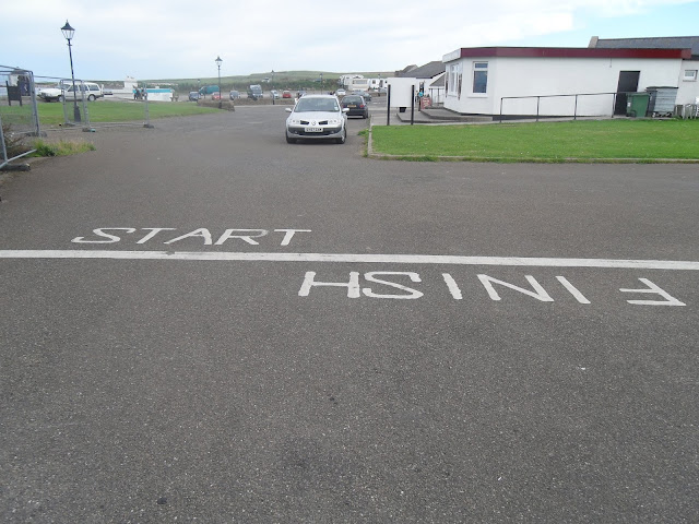
Then decided I might as well start walking early too! There is a start/finish line for end-to-enders outside the sadly derelict John o'Groats Hotel. I left from the line and enjoyed a very pleasant walk along beaches and cliffs to Duncansby Head and Stacks. Duncansby Head, a couple of miles east of John o'Groats, is the true North East extreme point of Great Britain and The Stacks are a natural wonder well worth visiting. I walked back to my guest house by road and noted that my Garmin GPS device showed 5.90 miles.

On Friday morning after breakfast I continued from where I had stopped the evening before, the front door of my guesthouse which was about half a mile south of the start/finish line. My walk was now well and truly underway. The road to Keiss was fairly desolate, mainly moorland and fields of sheep. After passing through Keiss I walked down a short lane to the beach at Sinclair's Bay. From there I had a very enjoyable 5 mile stroll on the deserted sands until the beach ran out next to a large home that resembles a castle. After getting momentarily lost in the grounds I re-emerged on the A99 just outside of Wick. The 16 miles to Wick had flown by, so I hung around long enough to eat both lunch and dinner. After spending 4 hours in Wick I pressed on, eventually stopping at Mid Clyth where I wild camped in undergrowth behind a disused cottage. I slept well, very content with my first days progress.

Weather; Overcast and windy, a few light showers at lunchtime. Max 16C

Mileage today 31.90 (includes 5.90 on Thursday 19th), walking time 8hrs 7mins,
average walking speed 3.9mph

GPS tracks; click here  and  here


Duncansby Stacks
The start/finish line for end-to-enders at John o'Groats


The deserted sands of Sinclairs Bay


Wednesday, 18 August 2010

My journey begins today - thanks for all the good luck messages.

In a couple of hours my journey will begin when Lea will drive me to Winterbourne Abbas in Dorset. My parents will meet us there and take me the rest of the way to their home in Fordingbridge. Tomorrow  morning (Thursday) it'll be an early start (don't worry, I'm used to them!) to make sure I'm at Southampton Airport in time for my 7-00am flight to Edinburgh with Flybe. From there I will catch a connecting flight for the short hop up to Wick (a short hop in flying terms, not in walking terms!).

At the moment I'm making doubly sure everything is packed. There is only one decision left to make; do I add a fair bit of weight to my pack by adding the two books I would like to take? Maybe I should I take just one? Or do I leave them both behind?

Over the last few days I have received lots of good luck cards, mainly from customers on my milkround. Also many good luck messages have arrived over the internet. Thank-you very much to all of you, they have touched me and will be in my mind as I walk. Again I must thank everybody who has made a donation to MacMillan Cancer Support, the generosity shown to this great cause will give me more determination than anything else to push through the tough times during my challenging journey.

During my walk the best way to keep up-to-date with my progress will be by following me on Twitter. I shall be posting location details and photos live from my iPhone regularly. The link below takes you to my Twitter feed;

http://twitter.com/GaryLQ

My next blog post will be from Scotland!

Gary

Sunday, 15 August 2010

Only 5 days to go! Last minute preparations.

Hello everybody,

I'm delighted to report that very generous donations continue to come in for MacMillan, I've been overwhelmed by the generosity shown by people before I've even made my first step. Every mile along the way is now going to feel more worthwhile than ever. If you would like to make a donation please visit my Just Giving page by clicking here.

On Monday and Tuesday 15th/16th August I'll be working on my milkround as usual. My Journey begins on Wednesday 17th when I travel to the New Forest for an overnight stay with relatives. They live close to Southampton Airport where I'll need to be first thing on Thursday morning to catch my 7-00am flight up to Wick (via Edinburgh). A bus will take me the last 20 miles from Wick up to John O'Groats. After a night in a B&B my walk will officially begin at around 9-00am on Friday morning.

At the moment I'm very busy with last minute preparations, tying up all the loose ends at home and liaising with the MacMillan and Milk & More teams to make sure everything runs as smoothly as possible while I'm on the road.

I will start my walk feeling I've prepared as well as possible, more than a year of planning has gone into this event. There has been no compromise between price and quality when it comes to kit, I've only bought tried and tested hi-tech lightweight gear specificly designed for long distance walking. My route planning has gone into much fine detail for the whole journey. As for fitness, I've put in at least 500 practise miles over the last few months, always carrying the full weight of kit that needs to go on the walk with me, I feel in great shape and can't wait to get going. There are many very good websites that have helped me prepare for such a daunting task, travel journalist Mark Moxon's excellent website about John O'Groats to Lands End walking has been particularly useful.

Though I will I begin full of confidence I'm certainly not making the mistake of underestimating my task. Good fortune will have to be on my side, I'm aware that injury and illness could strike me at any time. There are many other things that could affect my progress, severe weather events for example. For these reasons I have chosen not to commit myself to a fixed timetable, my walk will take as long as it takes. If I reach the point of exhaustion or I'm suffering from injury I will stop and take rest days to give me the best chance of  lasting the entire distance.

Click here to see an accurate map and graphs of my final practise walk; a 10 mile stroll around Exmouth completed after work on Friday afternoon. This data was recorded on my hand-held Garmin GPS device. I'm hoping to post similar maps and graphs for my entire walk on this blog, however this will only be possible if I can get occasional access to a PC, unfortunately the data cannot be uploaded via my iPhone.

Gary

Saturday, 7 August 2010

Route planning and other news

Route planning

One of the joys of a walk between John O'Groats and Lands End (or vice-versa) is that there is no set route. As long as you start and finish at those two points you can go which ever way you choose.

The straight-line distance from Land's End to John O' Groats is approximately 603 miles, but that passes over stretches of the Irish Sea. The shortest distance by road is 874 miles. Many end-to-end walkers opt to take a scenic route and end up walking as much as 1,200 miles, or even more.

My route has been in the planning stage for several months. When I leave John O'Groats the first 118 miles or so will involve walking along the A9 and A99 to Inverness. From there I will head south west along the Great Glen Way until I reach Fort William around 73 miles later. The 96 miles of The West Highland Way, a scenic but challenging off-road track, will take me from Fort William to the outskirts of Glasgow. From there I will head south until I enter England at Gretna Green.

I have chosen a route through England that enables me to visit my fellow milkmen at 17 Milk & More depots, including my home depot in Exeter. The Milk & More team's backing has been crucial to getting my walk off the ground, without their generous support I simply wouldn't be able to afford to do it. I'm hoping that my depot visits will generate some PR opportunities and boost the sum raised for MacMillan. The Milk & More depots I have chosen to visit are as follows;

Wigan
Howley (Warrington)
Nothwich
Crewe
Stoke
Burntwood
West Bromwich
Redditch
Worcester
Gloucester
Yate (Bristol)
Weston-Super-Mare
Taunton
Exeter
Torquay
Plymouth
Camborne

If anybody living close to my route can offer to put me up for the night I'm very interested, please get in touch.

Seasoned hikers who prefer scenic off-road walks will probably be horrified to realise that my path will take me through several urban centres including Glasgow, Birmingham and Bristol. However the route is of my choosing and I don't mind passing through occasional towns and cities if it gives me the opportunity to visit my colleagues and the possibility of raising more money for MacMillan.

When my walk commences I will be carrying no paper maps whatsoever, though I expect I'll need to buy one or two on my way. While planning I've typed up over 100 pages of detailed route notes and generated 120 maps on my laptop using some very useful mapping websites. These have all been stored on my iPhone, which will be a crucial tool on my walk. I will be able to views all my maps and notes even when I have no mobile signal. A copy of all my notes and maps will also be taken on a USB stick to give me the opportunity to have physical copies printed off when the need arises. My hand-held Garmin GPS device will also aid navigation.

In total my planned route comes in at just over 950 miles, however I'm bound to stray off the path quite often when I'm seeking food, other provisions and places to stay. Also it's inevitable that I'll take a wrong turn every now and then and end up putting in some unexpected extra miles for various reasons. So all-in-all I'm expecting to walk around 1000 miles, in fact I think it will feel good if I actually do manage to break the 1000 mile barrier before I reach the finish line. My GPS device will record the exact daily distances and I will publish them on this blog.

Other news

As I type I have already raised £1,853 for MacMillan, and that sum doesn't include the gift-aid element that will be claimed on the majority of donations at a later stage. I have been over-whelmed by peoples generosity and I'm delighted to reach this figure two weeks before I even start walking. I'm now more confident than ever that I will be able to reach my £5,000 target. Please keep them coming folks!

My training is almost complete, my final 20 mile practise (10 miles each way to and from work) will be completed on Wednesday 18th, with shorter walks to follow on the Thursday and Friday. I estimate that I have walked at least 500 practise miles over the last few months, always wearing and carrying all my JOGLE kit. I'm very lucky to have beautiful countryside to explore in East Devon. My practise boots (that I've also been wearing at work) are almost completely worn out, they're identical to the brand-new ones I'm taking up to John O'Groats with me, I'm going to start wearing that pair in a week before I leave.

For those of you familiar with Twitter, I will be tweeting as I walk. The tweets will include progress reports, photos and anything else of interest. The Tweets will also automatically update my Facebook status. My iPhone has a GPS facility, this means all the tweets will include precise geographical data. Shortly before the walk starts I will add my Twitter address to this blog.

Gary

Sunday, 1 August 2010

Welcome

Hello everybody and welcome to my blog!

In less than three weeks I shall be setting off on my epic walk. I'm fully prepared and can't wait to get going. I've been planning this walk for at least a year now. Although the milkround gives me a good foundation of fitness, I've been going out on regular practise walks for the last 5 months.

As I'm walking solo and unsupported I will be carrying a fairly weighty rucksack which contains all my essentials for the journey. This includes a one-man tent, sleeping bag, pillow, waterproofs, changes of clothes, toiletries, first aid kit, GPS device, mobile phone with charger and back-up battery, etc. etc. The total weight of my kit is around 15KG. All of my practise walks have been completed carrying the full load to get me used to the extra weight. I have carefully researched my kit and purchased high-tech lightweight items whenever possible.

My milkround is a Dairy Crest Milk & More franchise. The Milk & More team have given me very generous support without which my walk would not be possible. During my journey I will be dropping into around 15 Milk & More depots, including the Exeter depot where my own round is based. www.milkandmore.co.uk

Two things have motivated me to walk. Firstly to walk the famous John O'Groats to Lands End has always been an ambition of mine, I like a bit of adventure and I cannot think of a better way to see our beautiful country. Secondly it gives me a great opportunity to raise money for MacMillan Cancer Support, a fantastic charity which do wonderful work in the community for cancer sufferers and their families. If you would like to help make my walk worthwhile please make a donation to Macmillan via my Just Giving page. All donations will passed to MacMillan in full, no deductions are being made for expenses. Click Here to make a donation.

The map below shows a rough outline of my intended route. I'm not going to be walking to a set schedule, my route is expected to total around 1000 miles. It is my intention to average 20 miles per day and complete my walk within 8 weeks. Each day I will record precise data about my route and the distance walked using a handheld GPS device.

Click here to see an article about my walk in the Express and Echo.


About Me

My photo
Exmouth, Devon, United Kingdom
Hi :) I'm a 49yo father of three from Exmouth, a lovely seaside town in Devon. In parts of Exeter I'm well known as the local milkman where I've been making traditional doorstep deliveries for 15 years.